It’s the Jet Stream!

In this NASA visualization, the fastest winds are in red; slower winds are in blue. Credit: NASA
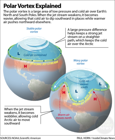
It might seem counterintuitive, but global warming plays a role in blasts of bitter cold weather. The reason: it influences the jet stream.
This article by Bob Berwyn, published in INSIDECLIMATE NEWS on February 2, 2018, gives a good explanation of what happened to our spring weather starting on April 14th.
Excerts from the article:
“Arctic temperatures are rising twice as fast as the global average. And that’s reducing the temperature contrast that’s one of the jet stream’s main engines” says Rutgers University climate scientist Jennifer Francis. She has found “robust relationships” between Arctic warming and a wavier jet stream.
… over the past several decades, the jet stream has weakened. There’s also evidence that as it wobbles, it can get stuck out of kilter, which can lead to more persistent weather extremes, including heat waves, cold snaps, droughts and flooding.
Melting Arctic sea ice may be behind this year’s delayed spring: scientists
The Toronto Star ran this Canadian Press Article on April 17th, exploring the relationships between melting Arctic ice, the weakened jet stream and weather extremes.
Excerpts below:
Why? Icy Arctic air is normally held back by a strong, high-altitude, west-to-east river of air called the jet stream.
The jet stream is powered by the temperature difference between the Arctic and mid-latitudes. But the Arctic is warming faster than anywhere on Earth, especially this year, when temperatures at the North Pole were up to 30 degrees above normal.
Some climatologists say this is the future — long stretches of freakishly unseasonable weather that flip to something else on a dime.
Follow PCM on Social Media